Sentinel-1 Satellite Imagery for Earthquake Displacement Detection
Exploring advanced techniques for monitoring seismic activities.
Exploring advanced techniques for monitoring seismic activities.
Earthquakes are one of the most destructive natural disasters, causing widespread damage and loss of life. Timely and accurate assessment of earthquake damage is crucial for effective emergency response and resource allocation. This report demonstrates the practical application of Sentinel-1 satellite imagery for earthquake displacement detection using the Differential Interferometry (DInSAR) technique.
We utilized Sentinel-1 satellite images acquired before and after the 2017 Iran earthquake event. The images were downloaded from the Copernicus website in SLC format, which contains amplitude and phase information. The phase information is essential for measuring ground changes, such as displacements caused by earthquakes.
Images were unzipped and imported into SNAP software, a freely available tool for Sentinel-1 image processing. We followed a step-by-step approach to process the images, including:
We selected the Co-Registration option from the Radar menu, ensuring the reference and secondary images were set correctly. The TOPSAR Splitting step was performed to improve processing accuracy by separating leading and trailing pulses.
We combined the radar images to extract ground displacement changes. The S1 TOPS Deburst step reassembled parts of the image captured in TOPS mode into a complete image. Topographic Phase Removal was conducted to eliminate topographic variations, isolating real ground displacement changes.
Goldstein filtering was applied to reduce noise and correct phase in the radar data. The unwrapping stage resolved phase ambiguities, producing a continuous phase map essential for analyzing surface displacements.
We converted phase changes into physical displacements of the Earth's surface using the Phase-to-Displacement process. Range Doppler Trend Correction adjusted radar images for topographic distortions, resulting in a more accurate representation of the Earth's surface.
The displacement map provides critical insights into the geographical context of the earthquake, highlighting key affected areas such as Sulaymaniyah, Halabja, and Darbandikhan along the Iran-Iraq border. The use of a color gradient effectively illustrates varying levels of ground displacement, with darker colors indicating more significant movement. This visualization allows for the rapid identification of the most severely impacted zones, which is essential for timely emergency response. Additionally, the map reveals concentric rings of displacement, suggesting that the intensity of ground movement diminishes with increasing distance from the epicenter, a common characteristic in seismic events. The integration of Geographic Information Systems (GIS) enhances the analysis by visualizing complex data, thus improving our understanding of spatial relationships and patterns associated with the earthquake's impact. This analysis is not only valuable for assessing infrastructure damage but also plays a crucial role in disaster response planning and resource allocation for emergency services. By combining satellite imagery and seismic sensor data, the study ensures accurate measurement of ground displacement, thereby enhancing the reliability of the findings and informing future recovery efforts.
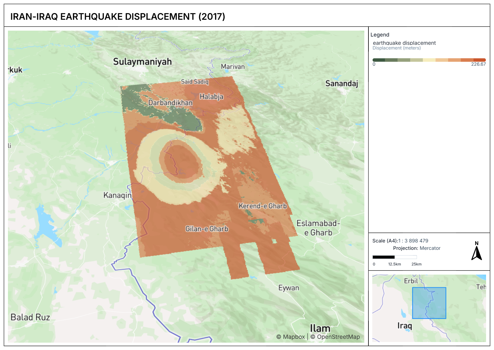
The results of the DInSAR analysis provide a unique opportunity to study the earthquake-induced deformation mechanisms. The radial pattern of displacement, characteristic of a compressional deformation mechanism, suggests that the earthquake triggered a complex sequence of faulting and deformation processes. The high precision of the DInSAR results enables a detailed analysis of the displacement pattern, allowing for a better understanding of the underlying mechanisms driving the deformation. This information can be used to inform seismic hazard assessments, emergency response strategies, and urban planning initiatives, ultimately contributing to the development of more resilient communities.
This practical report highlights the potential of Sentinel-1 satellite imagery for earthquake displacement detection. The DInSAR technique, combined with SNAP software, provides a powerful tool for assessing earthquake damage and informing emergency response strategies. We recommend further research and development to improve the accuracy and efficiency of this approach, as well as its integration with other data sources and technologies.